
Wideband Operating Frequency
The entire series supports multi-frequency operation from 200 to 700 kHz, allowing dynamic selection of the optimal frequency based on water depth and application scenarios (e.g., mapping, detection).
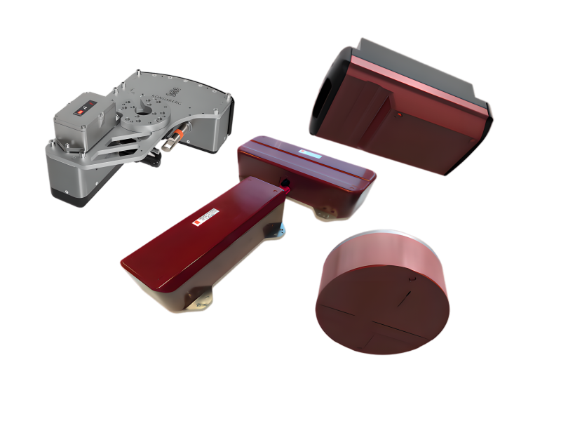
The Kongsberg EM 2040 series multibeam echo sounder system is a world-leading solution for seabed terrain mapping and detection. This series covers a full range of application scenarios, from vessel-mounted installations to integration on USVs, ROVs, and AUVs. Renowned for its high resolution, high accuracy, and exceptional reliability, it fully meets and exceeds the highest international standards such as IHO Special Order and LINZ specifications.
This series comprises four core products, forming a complete technological lineup:
EM 2040C MKII: Circular dual-transducer design, 200° wide swath, cost-effective.
EM 2040P MKII: Compact structure, portable installation.
EM 2040 MKII — The series' high-performance flagship. Split transmit/receive design. 0.4°×0.7° ultra-narrow beams. 170° (single) / 220° (dual) swath. 6000m depth-rated option. The benchmark for professional ocean engineering and deep-water applications.
EM 2042 — Latest-generation lightweight, energy-efficient evolution of EM2040. Features QuadSwath™ and PredictivePitch™ for unparalleled data density and accuracy—ideal for small USVs in challenging sea conditions and high-speed surveys.
The entire series supports multi-frequency operation from 200 to 700 kHz, allowing dynamic selection of the optimal frequency based on water depth and application scenarios (e.g., mapping, detection).
By alternating transmission of multiple frequencies in a single pass, backscatter data for up to 5 frequencies can be acquired simultaneously, significantly enhancing seabed substrate classification capabilities.
Simultaneously supports CW (Continuous Wave) and FM (Frequency Modulated) pulses, combining the advantages of long-range operation and high resolution.
Equipped with 3D beam stabilization for roll, pitch, and yaw, ensuring data accuracy even with vessel motion.
Capable of displaying and logging full water column data for analyzing targets in the water (e.g., fish schools, gas seeps).
Supports optional configurations such as dual swath and multiple receivers to meet the most demanding survey coverage and data density requirements.
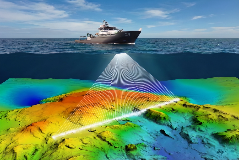
Acquires high-precision seabed topography to ensure navigation safety and dredging project efficiency.
Used for preliminary exploration and prospect assessment of offshore oil, gas, and mineral resources.
Supports surveys for submarine pipelines, cable routes, and inspection of underwater structures (e.g., wind turbine foundations).
Efficiently completes search and identification tasks for underwater targets such as shipwrecks and aircraft.
Provides foundational data for marine geology, geophysics, and hydrological research.
Perfectly integrates onto unmanned platforms such as USVs, AUVs, and ROVs to perform autonomous or remotely operated surveying tasks.
| Technical Specifications |
EM 2040C MKII |
EM 2040P MKII |
EM 2040 MKII |
EM 2042 |
| Frequency Range |
200 - 700 kHz |
200 - 700 kHz |
200 - 700 kHz |
150 - 700 kHz |
| Maximum Beams / Ping | 512 / 1024 (Dual Swath) / 1600 (Dual-head, Dual Swath) | 512 / 1024 (Dual Swath) | 512 (Single RX) / 1024 (Single RX Dual Swath) / 2048 (Dual RX Dual Swath) | Single RX: Up to 2048 Dual RX: Up to 4096 |
| Maximum Coverage Angle | Single head: 140° Dual head: 200° |
Up to 170° | Single RX: 170° Dual RX: 220° |
Single RX: 170° Dual RX: 220° |
| Maximum Depth Range | Max 520 m at 200 kHz (Dual head, cold water) | Max 600 m at 200 kHz (cold water) | Max 635 m at 200 kHz (cold water) | Max 600 m at 200 kHz |
| Depth Rating | 50 m or 1500 m (Deep water version) |
30m |
50 m or 6000 m (Deep water version) |
50m |
| Key Features | Compact integration, easy installation, cost-effective | Portable design, surface protection, optional integrated SVT | Split design, performance flagship, ultra-wide coverage, deep-water applications | Lightweight, supports QuadSwath™ and PredictivePitch™ functions |
| Unique Functions / Configurations | Dual-head configuration achieves 200° coverage | Optional integrated AML sound velocity sensor (SVT) | Supports Dual TX and Dual RX configurations.<|end▁of▁thinking|>Supports Dual TX and Dual RX configurations | Supports QuadSwath™. Options for built-in micro-MRU and SVT sensors |

Email: business@blueholeinstruments.com
Address: Gate 6, Building 29, Yuhu Nanyuan, Huanhu East Road, Jinghai District, Tianjin
© 2025-Now Tianjin Bluehole Instrument Co., LTD Copyright
Powered by:Chuangmeng Times
