Traditional manual diving inspections are high-risk, inefficient, and limited in coverage—often missing critical areas such as underwater dam faces, expansion joints, and flood discharge inlets.

Bluehole Instruments delivers a non-contact, high-efficiency, high-definition inspection solution combining surface survey sonar, high-performance ROVs, and multi-sensor acoustic/optical systems—purpose-built for underwater dam structure assessment.

Solution Value

  • 01

    Accurate Risk Identification

    High-definition acoustic imaging reveals subtle structural defects—enabling early detection and precise localization.

  • 02

    Revolutionary Efficiency Gain

    ROV-based sonar surveys far outperform manual diving—unrestricted by depth or visibility, with longer operational windows.in a longer operating window period.

  • 03

    Digital Asset Creation

    High-res acoustic imagery and 3D point clouds build a digital archive of underwater structures—providing precision data for safety assessments, maintenance decisions, and historical comparison.

  • 04

    Enhanced Safety & Cost Optimization

    Eliminates diver risk while reducing overall inspection costs and safety management complexity.

Core Equipment

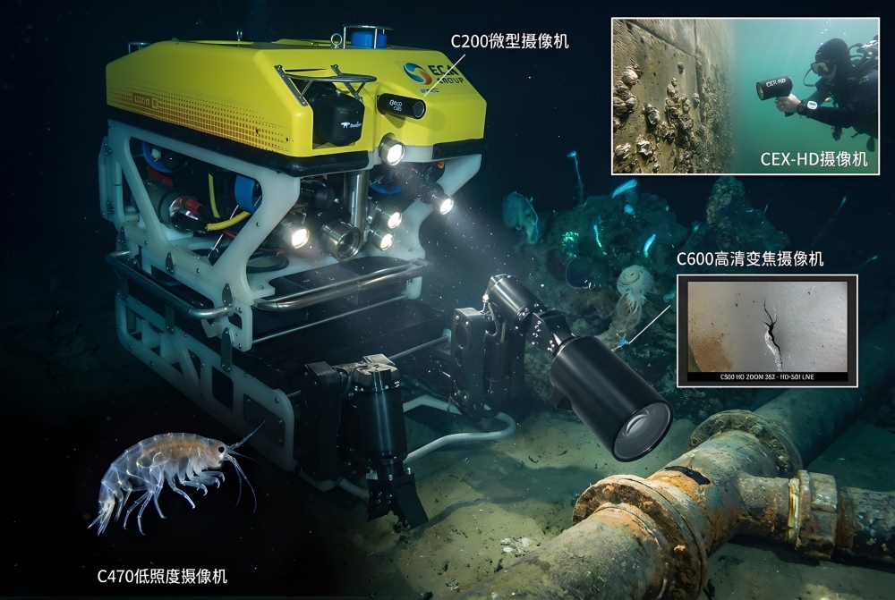
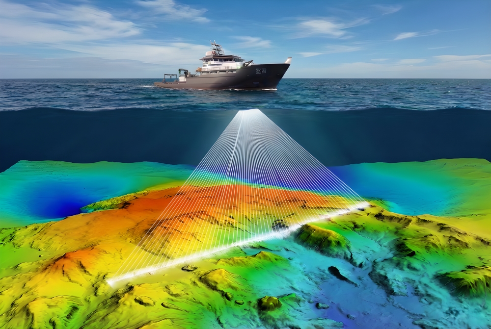
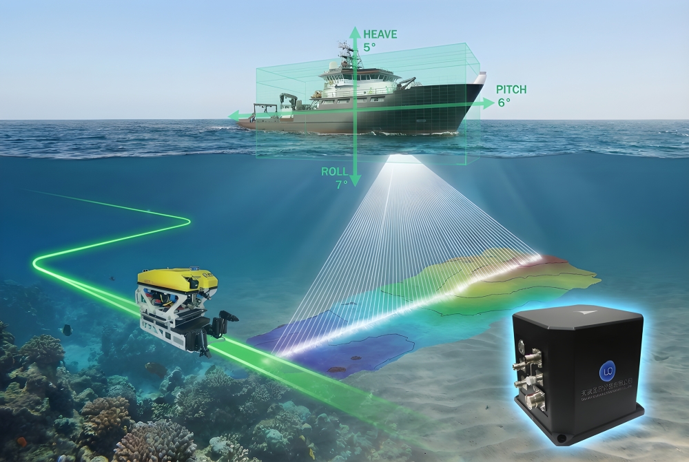
  • Kongsberg Flexview HF Series High-Frequency Multibeam Sonar

    Optimized for ROVs

    Compact and lightweight—just 3.75 kg in air—perfectly matched to observation-class ROVs, eliminating payload constraints.
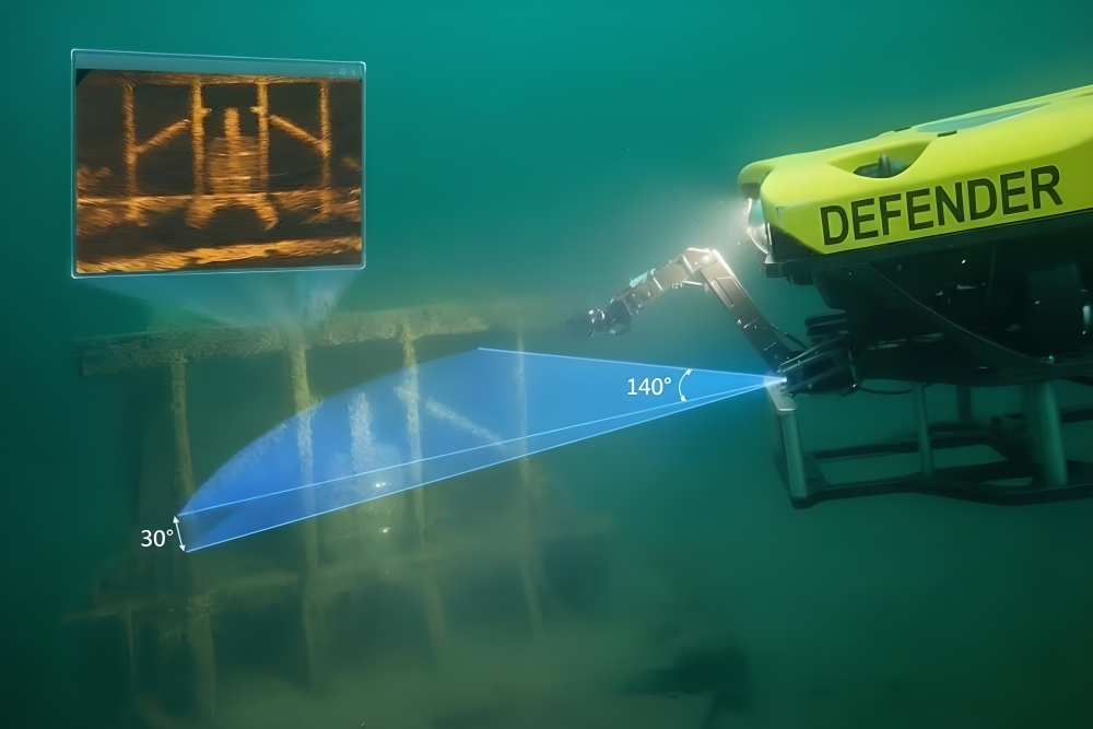
    HD Acoustic Vision

    Delivers distortion-free, high-resolution real-time imagery up to 100 meters across a 140° wide sector, with 1 cm range resolution.

    Flexible Imaging Modes

    700–1400 kHz multi-frequency operation—select the optimal frequency for broad-area surveys or detailed structural inspection.

    Rapid Maintenance Design

    Field-replaceable transducer ensures project continuity and maximizes equipment uptime.

  • ROS C-Series & SPECTATOR Underwater Camera Systems

    Full-Scene Imaging Coverage

    From shallow water (70m) to deep sea (6000m), and from 550TVL SD to 1080p Full HD—the full range adapts to diverse inspection needs including dam upstream faces, discharge gates, stilling basins, and deep foundation trenches.

    Extreme Low-Light Clarity

    The C470 delivers 0.0001 lux ultra-low-light sensitivity—capturing subtle defects such as cracks, seepage points, and concrete spalling in turbid forebay waters or deep, dark environments without auxiliary lighting.

    High-Magnification Precision Observation

    The C600, C1000, and SPECTATOR support up to 36x optical zoom—enabling remote magnification of critical details including gate seals, expansion joint deformation, and surface growth for non-contact, high-resolution inspection.

    Deep-Sea Rugged Design

    Core models feature titanium alloy housings with sapphire/tempered glass viewports, pressure-rated to 6000m—corrosion-resistant, impact-resistant, and engineered for long-term reliability in deep-water dam monitoring and periodic inspection tasks.

  • ROS SEASTAR & Q/MV-LED Series Professional Lighting Systems

    Full-Scene Precision Beam Coverage

    SEASTAR series offers 110° flood or 38° spot options. Q/MV-LED series delivers three beam patterns: 80° flood, 80° high-brightness flood, and 38° spot—adapting to diverse inspection needs from wide-area dam face scanning to localized gate slot focus and crack close-ups.

    Deep-Sea Pressure Rating & Rugged Protection

    TSEASTAR series and MV-LED II are pressure-rated to 6000m. Q-LED series offers 4000-6000m options. Hard anodized aluminum housings ensure reliable long-term operation in deep forebay environments under high pressure.

    Field-Serviceable Modular Design

    All internal components of the SEASTAR series support tool-free field maintenance—significantly reducing downtime and lifecycle costs during long-term dam inspection campaigns.

    Professional Video-Grade Flicker-Free Lighting

    SEASTAR PAL models support phase and amplitude dimming—eliminating flicker with HD camera systems for true-to-life imaging of concrete surfaces, seepage marks, and fine cracks.

  • Kongsberg EM2040 Series Shallow Water Multibeam Echosounder

    High-Definition Dam Structure Imaging

    Ultra-narrow beams (0.4°×0.7°) combined with 200-700kHz broadband frequency agility deliver cm-resolution 3D terrain data in forebay areas—clearly identifying scour pits, cracks, concrete spalling, and toe undermining to support structural safety assessment.

    Adaptable to Any Platform

    Four models—EM 2040C MKII, EM 2040P MKII, EM 2040 MKII, and EM 2042—cover surface vessels, USVs, and ROVs, meeting inspection needs across reservoirs, tailwaters, and gate areas.

    3D Beam Stabilization

    Real-time roll, pitch, and yaw stabilization ensures precise beam targeting in complex forebay currents—delivering continuous, full-coverage scans of dam faces and gate areas with zero blind spots.

    Multi-Frequency Sediment Classification

    Single-pass multi-frequency captures sediment type and distribution data in forebay areas—distinguishing silt, sand, and gravel for reservoir capacity calculations, sediment management, and evolution analysis.

    Real-Time Water Column Monitoring

    Full water column data recording and display detects anomalous seepage bubbles and stratified flow—supporting seepage monitoring, environmental assessment, and emergency response decisions.

  • Sagsea Series Fiber Optic Inertial Navigation Unit

    High-Precision Attitude & Heave Measurement

    Heading accuracy ≤0.05° secφ, attitude accuracy ≤0.01°, real-time heave accuracy 5cm or 5%—providing stable, precise vessel motion data for multibeam systems to achieve mm-level reconstruction of forebay terrain, toe undermining areas, and gate slots.

    All-Source Navigation Seamless Switching

    Integrated GPS, BeiDou PPP, and RTK multi-mode positioning with automatic switching between satellite and pure inertial navigation—maintaining continuous high-precision positioning in canyon reservoirs and high-dam shadow areas for full forebay coverage.

    Modular Split-Body Deployment

    IMU supports independent underwater deployment; deck unit integrates GNSS receiver—adaptable to survey vessels, USVs, and ROVs for flexible inspection of upstream faces, discharge gates, stilling basins, and downstream riverbeds.

    Large-Capacity Full Data Logging

    Built-in 32G storage records complete inertial data—enabling tight-coupling post-processing to further optimize dam deformation monitoring accuracy, providing reliable data for structural safety assessment and long-term evolution analysis.

  • MPS Series USBL Acoustic Positioning System

    High-Precision Underwater Positioning

    Optimal positioning accuracy up to 10cm + 0.5% × slant range, supporting simultaneous multi-target tracking (up to 4)—enabling real-time position tracking of ROVs, divers, or towed bodies in forebay areas for controlled, traceable inspection of dam faces, gate slots, and toe undermining zones.

    Full Attitude Automatic Compensation

    Built-in high-precision heading and attitude sensor with factory-installed error correction—calibration-free for users, ensuring continuous and stable positioning data in complex canyon terrain and currents, eliminating vessel motion-induced errors.

    Deep-Water Capability

    Transponder rated to 6000m—easily covering large reservoir and high-dam deep-water inspection needs, supporting precise positioning and repeat surveys of deep dam faces, deep discharge tunnels, and foundation trenches.

    Multiple Coordinate Real-Time Output

    Supports real-time relative and absolute position output—directly georeferencing defect data acquired by underwater inspection tools to a geodetic coordinate system for multi-phase data overlay comparison and dam deformation analysis.

  • High-Performance Observation-Class ROV

    Precision Inspection in Low-Flow Environments

    Neutrally buoyant (freshwater) / slightly positive (seawater) design with 6-DOF IMU and dual magnetometers—enabling cm-level positioning and automatic station-keeping in reservoir forebay still water for stable observation of dam faces and gate slots.

    HD Vision for Fine Imaging

    1080p HD camera, 110° horizontal FOV, ±90° tilt adjustment, with 2/4 dimmable 1500-lumen LED lights—clearly capturing fine defects such as surface cracks, concrete spalling, seepage points, and gate rail corrosion.

    Modular Sonar Expansion

    Supports Ping360 scanning sonar or Sonoptix multibeam imaging sonar—generating real-time forebay terrain profiles and 3D underwater structure images in low-visibility water, accurately identifying toe undermining zones, sediment distribution, and potential seepage paths.

    Open-Source Ecosystem & Secondary Development

    Compatible with ArduSub open-source firmware—supports autonomous mission planning and depth hold. Researchers can develop automated inspection routines for standardized, fixed-depth, fixed-distance data acquisition across dam faces.