As offshore wind expands, long-term farm safety is critical. Scour threatens monopile foundations and submarine cables—risking structural damage, soaring costs, and safety failures.

Leveraging years of ocean expertise, Bluehole Instruments delivers intelligent, high-precision scour monitoring—empowering end-to-end management from early warning to informed decision.

Solution Value

  • 01

    Risk Avoidance at Planning Stage

    Identify seabed obstructions and unstable geological features early—optimizing route design and mitigating potential risks before construction begins.

  • 02

    Installation Quality Assurance

    Post-lay burial depth and free-span inspection ensures compliance with design specifications—securing initial operational safety.

  • 03

    O&M Cost Optimization

    Periodic inspections detect free spans, exposure, or excessive burial early—guiding targeted intervention and preventing catastrophic failures.catastrophic failures.

  • 04

    Data Asset Building

    Establish a high-precision database of cable corridor topography, morphology, and geology—providing authoritative evidence for lifecycle asset management and insurance claims.

Core Equipment

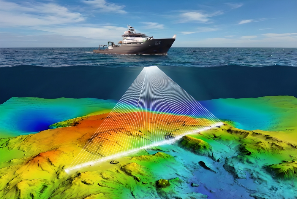
  • Kongsberg EM Series Multibeam System

    High-Resolution Seabed Imaging

    Precisely maps the micro-topography of cable route corridors, identifying features such as sand waves, rock outcrops, and gullies.

    Cable Condition Assessment

    High-frequency capabilities enable detection of minor free-spanning or exposure of cables after lay.

  • Marine Magnetics High-Precision Marine Magnetometer

    Dead-Zone-Free Detection

    Accurately detects ferromagnetic objects (e.g., shipwrecks, UXO, abandoned pipelines) along the route—providing critical data for route clearance and safe avoidance.

    Zero Heading Error

    Ensures seamless data integration across survey lines, generating highly reliable magnetic anomaly maps—eliminating the risk of missed targets.

  • EIVA ScanFish Intelligent Dragged Detection Platform

    Modular Integration

    Flexibly integrates multibeam, side scan sonar, sub-bottom profiler, and magnetometer for simultaneous mapping of terrain, seabed features, shallow geology, and magnetic targets (e.g., abandoned anchor chains).

    Superior Stability

    3D Steering enables precise altitude or terrain-following flight—ensuring continuous, high-quality data acquisition even in complex sea conditions.

    Efficient Full Coverage

    As a high-efficiency wide-swath survey tool, it significantly outperforms conventional shipborne single-point measurements—greatly enhancing route survey and inspection efficiency.

  • Integrated Data Processing & Delivery

    Streamlined Workflow

    Leveraging professional software platforms such as QPS, CARIS, and EIVA NaviSuite, we provide one-stop services—from multi-source data acquisition and fusion processing to the generation of standard deliverables including bathymetric maps, seabed feature maps, geological interpretation maps, and magnetic target distribution charts.

    Customized Reporting

    Delivers detailed technical reports tailored to industry standards and client requirements—complete with risk assessments and route recommendations.