As offshore wind capacity grows, long-term farm safety is critical. Scour threatens monopile foundations and submarine cables—risking structural damage, soaring costs, and safety failures.

Leveraging years of ocean expertise, Bluehole Instruments delivers intelligent, high-precision scour monitoring—enabling end-to-end management from early warning to informed decision.

Solution Value

  • 01

    Risk Early Warning

    Real-time monitoring of scour depth and extent—alerting you to structural risks before they escalate

  • 02

    Decision support

    Data-driven insights to guide scour protection design and cable laying strategies

  • 03

    Cost optimization

    Minimize unnecessary protection investments while extending asset lifespan.

  • 04

    Compliance Assurance

    Complies with international wind power safety standards and supports environmental permit applications

Core Equipment

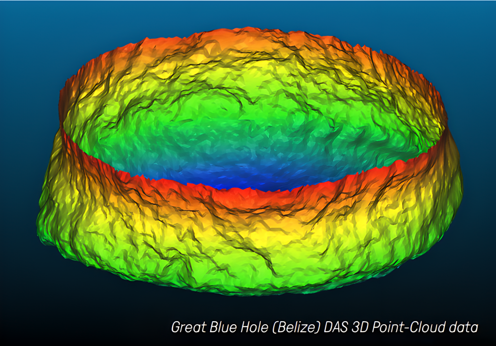
  • Kongsberg DAS Dual-Axis Scanning Sonar

    Designed for Long-Term Monitoring

    No exposed moving parts. Robust and reliable for prolonged deployment in harsh marine environments.

    Wide-Range 3D Scanning

    ±180° horizontal, -90° to +10° vertical scanning—direct output of X, Y, Z point cloud data.

    Flexible Network Deployment

    Supports multi-sensor networking for large-scale, long-term unattended monitoring of critical areas.

    Seamless Data Compatibility

    Output formats compatible with CAD and standard analysis software—easy integration and post-processing

  • Kongsberg EM 2040 Series Multibeam System

    HD Foundation Imaging

    Ultra-narrow beams (0.4°×0.7°) + 200-700kHz agility deliver cm-resolution bathymetry and backscatter—clearly identifying scour, marine growth, and micro-topography changes for structural assessment.

    Adaptable to Any Platform

    Four models (C MKII, P MKII, MKII, EM 2042) cover vessels, USVs, ROVs, and AUVs—for any depth or foundation type.

    3D Beam Stabilization

    Real-time roll, pitch, and yaw stabilization ensures precise targeting in complex currents

    Multi-Freq Seabed Classification

    Single-pass multi-frequency captures sediment data, distinguishing scour pit materials—key for evolution analysis and protection assessment.

    Real-Time Water Column Monitoring

    Full water column data detects bubble seepage and fish aggregation—supporting environmental monitoring during construction and operation.

  • Sagsea Series Fiber Optic Inertial Navigation Unit

    High-Precision Attitude & Heave

    Heading accuracy ≤0.05° secφ, attitude ≤0.01°, real-time heave 5cm or 5%—delivering stable, precise vessel motion data for multibeam systems to ensure true-to-life imaging of foundation terrain and scour holes.

    All-Source Navigation, Seamless Switching

    Integrated GPS, BeiDou PPP, and RTK with auto-switching between satellite and pure inertial modes—maintaining continuous high-precision positioning even in turbine-shadow or signal-drop zones for full 360° pile coverage.

    Modular Split-Body Deployment

    IMU supports independent subsea mounting; deck unit integrates GNSS receiver—adaptable to survey vessels, ROVs, and USVs for flexible inspection of piles, pipe racks, and suction anchors.

    Large-Capacity Full Data Logging

    Built-in 32GB storage records complete inertial data. Post-mission tight-coupling processing (e.g., POSPac) further refines pile inspection accuracy, delivering reliable data for millimeter-scale deformation analysis.

  • Kongsberg M3 multibeam sonar

    Multi-Frequency High Resolution

    700kHz–1400kHz selectable operating frequency delivers high-resolution seabed imaging—ideal for detailed structural inspection and terrain mapping.

    Dual-Mode Versatility

    Supports both side-scan and forward-looking modes in a single instrument—meeting monitoring needs across foundations, revetments, pipelines, and more.

    Optimized Detection Range

    30–100m effective range balances resolution and coverage—perfect for surveys around offshore wind facilities.

  • Remote monitoring system

    High protection and strong adaptability

    Equipped with IP66 protection level, it can operate stably in high temperature, high humidity, and high salt spray environments at sea.

    Multi mode reliable transmission

    Support LTE wireless and fiber optic wired transmission to ensure stable monitoring data and remote transmission back to the monitoring center

    Highly integrated and scalable

    Can conveniently integrate multiple sensors such as ADCP and sound velocity profiler to build an integrated comprehensive monitoring network