
All-Source Navigation and Multi-Mode Positioning
Integrates multi-mode positioning systems such as GPS, BeiDou PPP, and RTK, supporting seamless switching between GNSS-aided and pure inertial navigation.
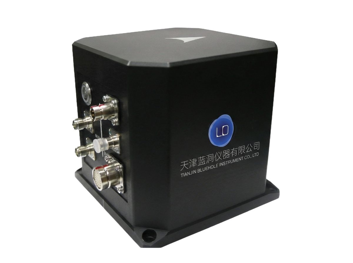
The Sagsea series Fiber Optic Inertial Navigation System is a professional-grade, high-precision navigation product developed by our company in collaboration with top domestic research institutions, specifically designed for marine surveying, underwater exploration, and engineering applications. This series is based on advanced fiber optic gyroscope technology, offering a complete navigation solution from deck-mounted units to deep-sea integrated systems. It features excellent positioning accuracy, attitude stability, and environmental adaptability, meeting the core requirements of various marine platforms for highly reliable navigation.
Integrates multi-mode positioning systems such as GPS, BeiDou PPP, and RTK, supporting seamless switching between GNSS-aided and pure inertial navigation.
Heading accuracy ≤0.05° sec φ, attitude accuracy ≤0.01°, real-time heave accuracy 5 cm or 5% of heave amplitude.
Built-in 32GB storage card, fully records all inertial data, supporting post-processing and analysis.
Provides 4 configurable RS-232/422 ports and supports 10/100M Ethernet communication, compatible with various peripherals for integration.
Utilizes a titanium alloy housing and an IP65 or higher protection rating, with resistance to salt spray and corrosion, adapting to harsh marine environments.
Supports modular installation (Sagsea I-D), where the IMU can be deployed underwater, and the deck unit integrates the GNSS receiver module.
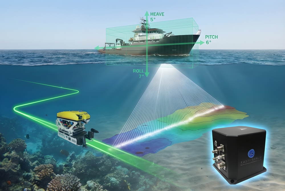
Provides high-precision position and attitude data for multibeam echo sounding and seabed terrain mapping.
Serves as the core navigation system for underwater platforms such as ROVs and AUVs, enabling precise positioning and path following.
Provides real-time motion parameters such as heave, roll, and pitch for engineering and research vessels.
Used for high-precision navigation in projects such as submarine pipeline laying, cable installation, and underwater construction.
Provides stable and reliable navigation support for underwater detection and surveillance systems.
Navigation Performance Specifications:
| Specification Item | Technical Parameters |
| GPS-Aided Navigation | |
| Heading Accuracy |
≤0.05° secφ(RMS) |
| Attitude Accuracy |
≤0.01° |
| Real-time Heave | 5 cm or 5% of heave amplitude (whichever is greater) |
| Delayed Heave | 2 cm or 2% of heave amplitude (whichever is greater) |
| Position Accuracy (Horizontal/Vertical) |
RTK:20mm+1ppm/30mm+1ppm BeiDou PPP: 0.3m / 0.6m |
| Pure Inertial Navigation | |
| Heading Accuracy | ≤0.1° (RMS, 1 hour) |
| Attitude Accuracy | ≤0.02° (RMS, 1 hour) |
| Position Accuracy | ≤2 nm (CEP50, 1 hour) |
Product Specification Comparison:
| Specification |
Sagsea I-s |
Sagsea I-30 |
Sagsea I-D |
| Product Positioning | Standard Deck-Mount Unit | Integrated Subsea Unit | Modular Deep-Water System |
| Installation Method | Deck Installation | Subsea Installation | IMU: Subsea Installation; Deck Unit: Standard Housing |
| Housing Material | Standard Protective Housing | Titanium Alloy | IMU: Titanium Alloy; Deck Unit: Standard Enclosure |
| Protection Rating |
IP65 |
Deep-Sea Rated Protection | IMU: Deep-Sea Rated Protection |
| Interface Configuration | 4 configurable RS-232/422 ports | 1x RS-422 receive + 3x RS-422 transmit | GNSS module integrated into deck unit |
| Cable Configuration | 10 m test cable | 10 m underwater mateable data cable (incl. power) | 10 m underwater mateable interconnecting cable |
| GNSS Integration | Standard GNSS board | Built-in underwater GNSS module | GNSS receiver module integrated into deck unit |
| Debugging Interface | Standard interface | USB + Ethernet + Debug Serial Port | Standard debugging interface |
| Dimensions |
180×160×135mm |
190×190×173mm |
IMU same as I-30, deck unit configured separately |
| Key Features | Cost-effective, easy to install | Deep-water operation, fully integrated design | Flexible deployment, high precision in deep water |

Email: business@blueholeinstruments.com
Address: Gate 6, Building 29, Yuhu Nanyuan, Huanhu East Road, Jinghai District, Tianjin
© 2025-Now Tianjin Bluehole Instrument Co., LTD Copyright
Powered by:Chuangmeng Times
