
Rugged and durable
Specifically designed for high-current and harsh sea conditions, suitable for long-term deployment.
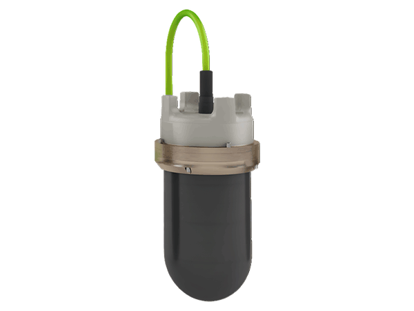
The DAS (Dual-Axis Scanning Sonar) is a profiling scanning system designed specifically for long-term marine monitoring. It features strong environmental adaptability, operating stably in high-current and harsh marine conditions, making it an ideal tool for long-term dynamic monitoring of the seabed or underwater structures.
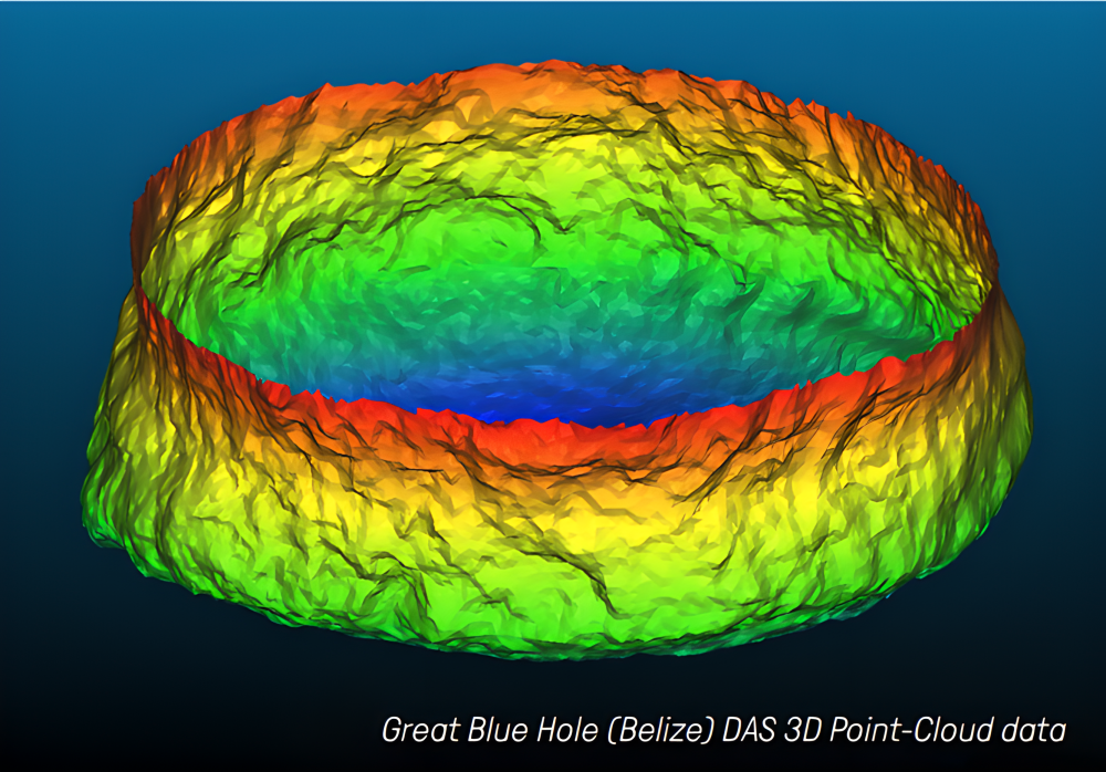
The DAS can operate in conjunction with MS1000 software or function in an "Autonomous Mode" to collect data independently, transmitting it back to shore via cable or wireless telemetry. Its continuous 3D scanning capability accurately captures dynamic changes in sediment scour and deposition. The output 3D point cloud data stream (X, Y, Z coordinates) is directly compatible with various digital terrain modeling software, facilitating high-precision topographic map generation and analysis.
Specifically designed for high-current and harsh sea conditions, suitable for long-term deployment.
Supports both MS1000 software control and autonomous operation modes, offering flexibility for various deployment scenarios.
Capable of operating multiple sonar heads simultaneously for large-area coverage.
Provides digitized terrain profile data, facilitating subsequent modeling and analysis.
Compact structure, easy to install, and supports both fixed or temporary deployment.
Long-term automated monitoring significantly reduces labor and maintenance costs.
Continuously monitors seabed scour and deposition dynamics around wind turbine foundations.
Scans bridge piers, docks, and other underwater infrastructure, as well as changes in the surrounding seabed.
Assesses sediment deposition and scouring risks near dam structures and intake areas.
Provides continuous and accurate terrain data to support scientific research and environmental monitoring.
| Parameters | Specifications |
| Range |
0.2 – 300 m |
| Range Resolution |
> 1 mm |
| Operating Frequency |
330 kHz |
| Beamwidth (2-way) | 2.2° Conical |
| Side Lobe Level (2-way) |
-30 dB |
| Horizontal Coverage |
360° |
| Vertical Coverage | +10° to -90° |
| Scan Step Angle |
0.225° – 7.2° |
| Depth Rating |
30 m |
| Communication Interface |
RS485 / RS232 |
| Input Voltage |
22 – 56 VDC |
| Dimensions (Diameter × Height) |
213 mm × 391 mm |
| Weight (in air / in water) |
20 kg / 11.5 kg |
| MS1000 Mode | Configured, operated, and logged via the MS1000 software |
| Autonomous Mode | Data acquisition via RS232/RS485 for integration with third-party systems |

Email: business@blueholeinstruments.com
Address: Gate 6, Building 29, Yuhu Nanyuan, Huanhu East Road, Jinghai District, Tianjin
© 2025-Now Tianjin Bluehole Instrument Co., LTD Copyright
Powered by:Chuangmeng Times
