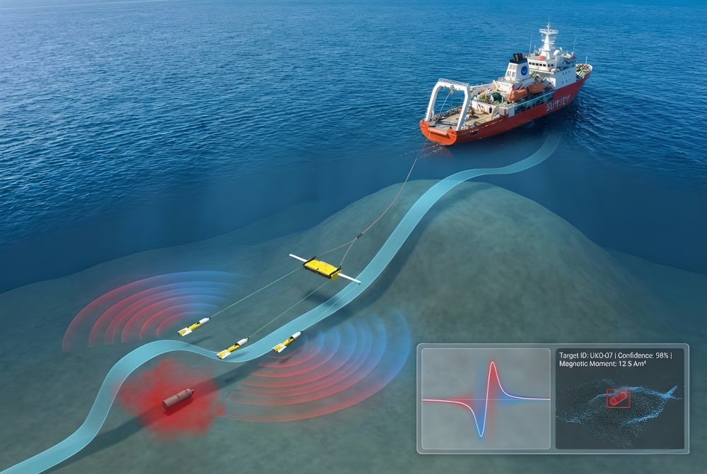
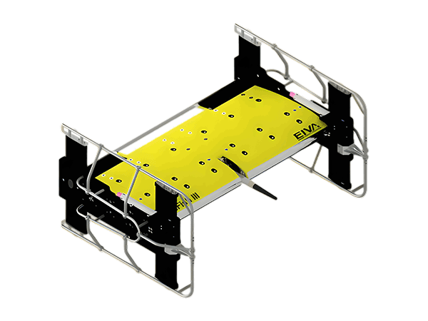
EIVA ScanFish ROTV series

EIVA ScanFish ROTV series

Modular intelligent drag platform reshapes efficient underwater detection

The EIVA ScanFish series is a highly modular remotely operated towed underwater platform (ROTV) designed specifically for modern ocean surveys. This series combines precision flight control technology with diverse sensor load capabilities, providing a comprehensive solution from marine science research, geophysical exploration to underwater engineering exploration. ScanFish ROTV has excellent stability and precise trajectory tracking capabilities, and can be equipped with various sensors including CTD, magnetometer, and side scan sonar. It automatically flies in preset depth or terrain tracking mode to ensure data acquisition quality. Its modular concept is deeply integrated with the NaviSuite software ecosystem at the core of EIVA, forming an integrated workflow from task planning, real-time collection, processing to result delivery.

EIVA ScanFish ROTV series

Key Features & Advantages

Main Applications

  • Underwater Unexploded Ordnance (UXO) Detection and Mine Countermeasures (MCM)

  • Investigation and Inspection of Submarine Cable and Pipeline Routing

  • Marine Geophysics and Hydrological Mapping

  • Marine science research (temperature salinity depth profile, water quality, water masses)

  • Environmental Monitoring and Impact Assessment

  • Underwater archaeology and search for sunken ships

  • Preliminary investigation of renewable energy (offshore wind power) sites

  • Port and waterway safety investigation

Specifications


Parameters/Model

ScanFish Rocio

ScanFish Katria

ScanFish XL

Equinox

3D Steering

core positioning Multi purpose oceanographic platform Specialized magnetometer/UXO survey platform High load comprehensive investigation platform Integrated side scan sonar solution Performance Enhancement Module
Key Features High load, multidisciplinary application Intelligent wide scan, high-sensitivity magnetometer Payload up to 400 kg Integrated Solstice Multi Aperture Sonar and High Precision Localization Add horizontal maneuverability to ScanFish
Payload high Optimization for magnetometer

400 kg

Integrated system, not applicable Not applicable
Integrated sensors CTD、 Water quality sensors, etc Magnetometer (optional) Multiple large sensors Wavefront Solstice Multi Aperture Side Scan Sonar Sonardyne SPRINT INS & USBL Four lateral rudder wing control modules
Supporting core software

NaviSuite Kuda

NaviSuite Kuda

NaviSuite Kuda

NaviSuite Kuda Pro+Processing (optional NaviPac Pro) Need to cooperate with control software such as NaviPac Pro
Investigation efficiency routine High (magnetic survey) Conventional (dependent on load) Extremely high, with an area coverage rate of up to 1.6 km ²/h Improve path tracking efficiency and data quality
Core application Marine Science, Environmental Research Magnetic anomaly detection, UXO investigation Large scale comprehensive geophysical survey High resolution UXO, SCM, archaeological survey All ScanFish applications that require precise 3D path tracking


Selection recommendations:

  • ScanFish Rocio: Suitable for general tasks that require multi parameter and multidisciplinary oceanographic observations, it is an ideal platform for scientific research and environmental monitoring.
  • ScanFish Katria: Designed specifically for underwater UXO surveys and magnetic exploration, its wide scan mode and optimization for magnetometers make it highly efficient in this field.
  • ScanFish XL: When the mission requires the use of large or heavy survey equipment (such as large side scan sonar, shallow profiling arrays), XL is an irreplaceable choice.
  • Equinox: The ultimate solution for users pursuing the highest standards of high-resolution side scan sonar data, particularly suitable for critical UXO troubleshooting and fine seabed classification projects.
  • 3D Steering: This is a key upgrade option that can significantly improve the performance of most ScanFish models. For any application that requires precise path tracking in complex water areas, such as cable inspection and terrain tracking, it is strongly recommended to configure it.