| Technical indicator category |
Specification |
| Supported data input |
| Sensor type |
Single beam, multi beam, side scan sonar, LiDAR, synthetic aperture sonar, interferometric sonar |
| Main supported formats |
Kongsberg (.all, .kmall), Teledyne Reson (.s7k), Hypack (.raw, .hsa), Eiva (.sbd), XTF, GSF, SEG-Y Waiting for over 40 industry standard formats |
| Core processing function |
| Sound velocity profile correction |
Support multi profile correction based on time/distance/(distance+time) |
| Vertical correction |
Support tide level model (including tide level network) and GPS vertical elevation+separation model |
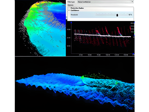
| Water depth data cleaning |
Depth/Range Filter, CUBE Algorithm, CARIS Mira AI Noise Classification, 3D Subset Editor |
| Grid Generation and Bands |
Support beam angle, uncertainty CUBE、 Shallow point real position and other methods; Generate multiple bands including depth, density, mean, standard deviation, uncertainty, and false design numbers |
| Backscatter processing |
SIPS backscatter engine provides beam pattern correction, gain normalization TVG、 Spot removal and other treatments |
| Side scan sonar processing |
Including drag position and slant distance correction; SIPS side scan mosaic provides weighted mixed correction |
| Visualization and Output |
| Supported Background image formats |
BSB/KAP, DXF/DWG, ESRI Shape, GeoTIFF, JPEG2000, NetCDF, BAG, S-57 wait
|
| 2D/3D visualization |
Support 2D plan view, 3D flight roaming, and regional 3D view |
| System and Integration |
| Automation tool |
Process Designer, Python API |
| Data Management Architecture |
HIPS file+SQLite database+CSAR spatial archive format |