
Powerful data storage architecture
Based on mature PostgreSQL and Oracle Spatial relational database management systems, Bathy DataBASE Server provides a secure and reliable mechanism for storing and managing water depth data.
CARIS Bathy DataBASE is an advanced water depth data management system built on the CSAR engine and mature RDBMS technology, providing a powerful and scalable storage and analysis solution for the growing sonar and LiDAR data. This system can easily integrate all data sources from historical measurement drawings to the latest high-density multibeam measurements, and centrally manage them on a unified platform.
Through intuitive tools for data manipulation, analysis, and compilation, users can confidently create various water depth measurement and mapping products. As a key tool for future adaptive management, Bathy DataBASE ensures that users can effectively address the growing challenges of data management.
Based on mature PostgreSQL and Oracle Spatial relational database management systems, Bathy DataBASE Server provides a secure and reliable mechanism for storing and managing water depth data.
By combining processing flows, historical measurement drawings are seamlessly integrated with the latest high-density multibeam measurement data in a single space.
Support 2D and 3D data visualization, display data on OGC services, and provide various tools such as differential analysis and profiling tools for data comparison.
Fully automate workflow through process models and Python scripts, supporting one click launch from BASE Editor, significantly improving processing efficiency.
Create mapping products such as isobaths, depth points, and meta objects, and use batch processing tools and APIs to load the depth dataset as fully attribute objects into Bathy DataBASE Server.
Clean and classify LiDAR point clouds in the subset editor, and create S-57 vector objects directly from the point cloud.
Provide a unified water depth data storage, management, and analysis platform for large surveying and mapping institutions and enterprises.
Generate nautical chart products such as isobaths and depth points that comply with international standards based on multi-source water depth data.
Provide accurate water depth and terrain data support for offshore wind power, submarine pipelines, port and waterway projects.
Support the large-scale water depth data analysis needs in scientific research such as marine geology and marine environment.
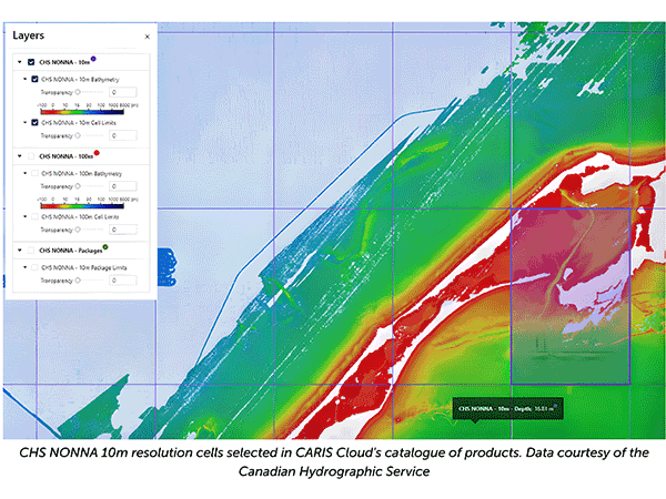
Automated publishing and sharing of water depth data through CARIS Cloud, providing timely data services for all stakeholders.
| Technical indicator | Specification |
| System architecture | |
| Core technology | Based on CSAR engine, supporting PostgreSQL and Oracle Spatial databases |
| Data standard | Support international standards such as IHO S-102 and comply with OGC service specifications |
| Cloud integration | Support CARIS Cloud integration to achieve automated data publishing |
|
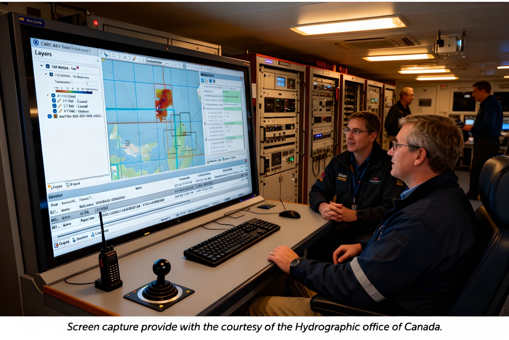
BASE Editor + BASE Manager |
|
| Processor | The latest generation multi-core CPU |
| Memory |
16 GB RAM |
| Storage | 7200 RPM hard drive or solid-state drive, with at least 1 GB of available installation space |
| Graphics card | NVidia or AMD display adapter, compatible with OpenGL 3.3 GPU, 2GB or larger graphics memory |
| Operating system | Windows 10 Professional 64 bit or Windows 11 Professional 64 bit |
|
Bathy DataBASE Server |
|
| Processor | The latest generation multi-core CPU |
| Memory |
16 GB RAM |
| Storage | 7200 RPM hard drive or solid-state drive, with at least 1 GB of available installation space |
| Operating system | Windows Server 2019 64 bit or Windows Server 2022 64 bit |
| Database support | PostgreSQL 14. x/15. x and PostGIS 3.3 or Oracle 19c Enterprise Edition, with Oracle Spatial |

Email: business@blueholeinstruments.com
Address: Gate 6, Building 29, Yuhu Nanyuan, Huanhu East Road, Jinghai District, Tianjin
© 2025-Now Tianjin Bluehole Instrument Co., LTD Copyright
Powered by:Chuangmeng Times
